Showing posts with label photo. Show all posts

Sunday, April 8, 2012

Partying With An Architect and A Skeleton in 1896

Toronto, 1896

This photo was taken by a guy named J.J. Woolnough. He obviously had a pretty weird sense of humour for a Victorian dude. He was born in England, in Dickensian London, where he started an apprenticeship as an architect when he was just 14 years old. A couple of years after that, for some reason that Google doesn't want to tell me, he sailed across the Atlantic and settled in Toronto. Here, over the course of the next few decades, he worked for a bunch of different architectural firms – and also developed an interest in amateur photography (pun oh-so-very-much intended).

He took this photo in 1896 using cutting edge technology: flash lights. That's what they called those trays of magnesium powder that old-timey photographers had to hold up for a flash while they ducked their heads under a hood to look through the camera. The flash lights meant you could take photos in places that would otherwise be too dark. And only occasionally did they set those places on fire and burn them to the ground.

This photo was originally given the caption "Good Company... but he has seen better days!"

Woolnough's architecture, though, is what he's remembered for. In the 1920s, he was named official City Architect; he designed all of Toronto's city-owned municipal buildings for the next seven years. His Art Deco designs are still all over the place. Like, say, these ones:

The Horse Palace
at the Canadian Nation Exhibition
The Riverdale Fire Station
Toronto Fire Station #324 on Gerrard East
The Rosedale Viaduct
the northern bridge on Glen Road
Montgomery's Police Station
on Yonge north of Eglinton, at Montgomery; now the Anne Johnston Health Station
Gallery 1313
on Queen West in Parkdale
The Toronto Water Works Maintenance Department
on Richmond West at the end of McCaul, just south of Java House
The Symes Road Destructor
an old trash-burning factory near Weston and St. Clair, now rundown but apparently the subject of revitalization efforts, which you can read about in The Grid here
I came across the skeleton photo in a great book full of beautiful and fascinating images, Inside Toronto: Urban Interiors 1880s to 1920s. You can buy it here or get it from the library here. The Biographical Dictionary of Architects in Canada has a brief biography of J.J. Woolnough here.

Thursday, February 16, 2012

What Queen and Gladstone Looked Like in 1893


Wow. Well, here you go hipsters, this is what it looked liked right outside the Gladstone Hotel in 1893. The Gladstone (which isn't in this photo, just out of sight to the right) would have only been four years old when this was taken. But the awkward "Dufferin jog" was already in place -- created by the railroad running by over the bridge in this photo. The bridge only had an underpass built on Queen, not Dufferin, meaning traffic traveling up and down Dufferin had to take a detour up Gladstone Avenue instead. It would take more than 100 years for a second underpass to be built; it just opened back in 2010.

Maybe even more interesting than that, though, is that in 1893 Toronto was in the middle of switching for horse-drawn streetcars to an electric system. According to the Wikipedia, the very first electric streetcar had started running just the year before; the final horse-drawn streetcar would be retired the year after. This photo captures that brief transition. The guy in the foreground is laying down Queen Street's first streetcar tracks, with the soon-to-be-obsolete horse-drawn transportation behind him.

I came across this photo in a TTC gallery put together by the Toronto Star, which you can check out here. I'll probably post another couple of photos from it over the next few weeks.

Monday, February 6, 2012

Mimico Creek Looked Really Freaking Beautiful Back in 1889

This, according to me, has to be one of the most beautifully pastoral photos ever taken of Toronto. It shows us what it looked like in 1889 at the very south-east corner of Etobicoke, in the spot where Mimico Creek meets Bonar Creek just before they empty into the lake. (Well, where they used to meet anyway; most of Bonar Creek was buried in the 1950s.)

It's just a few block west of the mouth of the Humber, and these days it's easily recognizable thanks to the gleaming white arch of the Mimico Creek Bridge (which purposefully looks like a smaller version of the bridge over the Humber).

Amazingly, even though it looks like these Victorian Torontonians are in the middle of the countryside, not far to the east of them our city was undergoing a crazily enormous boom, quickly becoming a full-blown metropolis. Between 1861 and 1901 the population quadrupled from about 60,000 to about 240,000 people.

I came across this photo in the veryvery good book I'm reading at the moment: HTO: Toronto's Water from Lake Iroquois to Lost River to Low-flow Toilets. So you can probably expect a bunch of water-related posts over the next little while. You can also buy the book for yourself from Coach House here or borrow it from the library here.

Tuesday, January 31, 2012

What Yonge & Queen Looked Like in 1915ish


This photo is looking north up Yonge Street from Queen Street in 1915ish. I don't have too terribly much to say about it, but here are a few tidbits. The entire left-hand side of the photo, the west side of Yonge, is now, of course, the Eaton's Centre. But the H. Knox and Company store you see here (which eventually become Woolworths) is still partially preserved. Across, the street from it, on the very right of the photo is the Bank of Montreal building which is also still there on the north-east corner of the intersection, though now it has a giant glass tower rising out of it. Behind that, you can see part of the sign for the Heintzman piano company, which will get its own post someday. Theodore August Heintzman came to Toronto from Germany in the 1800s and built a piano in his kitchen. When he sold it, he used the money to start his own company, which soon gained an international reputation for producing some of the highest quality pianos in the world. In 1915, Heintzman had recently bought the building you see here to use as a head office; we still call it "Heintzman Hall". These days, it's a heritage property and home to a Home Sense.

Wednesday, January 4, 2012

Damn, That's One Fine-Looking Post Office

This was our eighth General Post Office. It was on Adelaide, just a couple of blocks east of Yonge, at the head of Toronto Street. And it was, as you can see in this postcard from the very early 1900s, totally awesome.

That's because it was designed by Henry Langley, one of Toronto's most totally awesome architects. He also built a whole hell of a lot of our most beautiful churches: St. Michael's Cathedral at Church and Dundas; Metropolitan United at Church and Queen; Trinity-St. Paul's at Bloor and Spadina; Jarvis Street Baptist and St. Andrew's on the edges of Allan Gardens. He even did the delicate chapel at the Necropolis cemetery in Cabbagetown, where he's buried on the slopes of the Don Valley alongside the likes of William Lyon Mackenzie and George Brown. And he built plennnnty more than that, too.

Of course, due to people sometimes being stupid, the General Post Office was torn down. That was in 1958, as Toronto was swept by a short-sighted orgy of modernism. It was replaced by the nondescript glass office tower that stands boringly at the head of Toronto Street today.

And it's not alone. The two blocks of Toronto Street, between Adelaide and King, were once two of the most gorgeous blocks in the entire city. But now, just about all of the old buildings you can see in the photo below have been demolished and replaced. One of the few survivors is the impressive columned building on the very left – which just so happens to have been Toronto's seventh General Post Office.

I stumbled across the postcard on Wikimedia Commons here. And learned about the photo of Toronto Street thanks to a Heritage Toronto posts here. There's another photo of the eighth General Post Office here, from the '50s, not long before it was demolished.

Friday, December 2, 2011

Bloor & Spadina Was Pretty Beautiful Back in 1933 (Featuring Old-Timey Streetcars)


This is Bloor Street, just west of Spadina, in the summer of 1933. By then, it already been about 50 years since the Annex was annexed into the city of Toronto. But the growth hadn't stopped there, of course. By the time the 1920s rolled around, the city had begun to swallow up villages and neighbourhoods even further north, spreading up the escarpment into places like Moore Park and Forest Hill, and west too, through Parkdale. That's when we decided that our transportation system should be amalgamated as well: the TTC was officially born and a brand new fleet of streetcars hit the roads of Toronto.

You can see them here in the middle of the photo. They're called Peter Witt streetcars, named after the guy from Cleveland who designed them in the early 1900s. We had a few hundred of them, which apparently makes us one of their best-known homes, but they also appeared in cities all over North America and Europe: New York, Chicago, Detroit, Mexico City, Madrid, Naples, Milan... The TTC used them for about forty years, finally taking the last ones out of commission in the '60s, but in Milan, they are still about two hundred Peter Witt streetcars gliding through the streets, painted bright orange. A few of them have even made their way from Milan to the United States, where they grace the hills of San Francisco.

I found this photo on the Toronto Archives Flickr page (which rules). They've got an entire set dedicated to the Peter Witts. I'll post a few of my other favourites below and you can check out the full set here, read more about the streetcars on Transit Toronto here or in Agatha Barc's blogTO post here. You can also watch a little video of one of the streetcars in action here from the Halton County Radial Railway Museum, where they've got one you can ride.


The Peter Witts ran on different tracks from the ones we had before
 

Sunday, November 20, 2011

The QEW Looked A Whole Lot Different in 1939


The QEW started out as a much smaller highway called the Middle Road. It was built as a government works project during the Great Depression, connecting Toronto to Hamilton as an alternative between Lake Shore and Dundas, which were getting clogged with traffic. Not long after it was built, it was expanded and extended all the way to Niagara Falls, becoming Queen Elizabeth Way. It was modeled on the autobahns in Germany, the first of its kind in North America, with the longest uninterrupted stretch of streetlamps in the world. The stuttering King George VI was here to officially open it with his wife, Elizabeth, who it was named after. (You might know her better as the Queen Mum, or Helena Bonham Carter in The King's Speech.)

This photo was taken in Etobicoke around the time the highway officially opened. It shows the interchange with what's now Highway 427. Today, this spot is a tangle of concrete ramps in the midst of a big box wasteland just west of Kipling, not far from Sherway Gardens.

Here some more old photos of the highway, mostly found here and here.

The rural road in the days before the QEW
The royal opening ceremonies in St. Catherines, 1939
King George VI and Elizabeth on the QEW, 1939
The entrance to the QEW in Toronto, 1940
East of Oakville, 1938
Fruit trees in spring, Grimsby, 1949

Thursday, October 27, 2011

Photo: What Miss Toronto Looked Like in 1926


You might be familiar with this photo already, since it apparently inspired a mural on the side of the Rhino in Parkdale. It was taken at the very first Miss Toronto pageant ever, which was held in 1926, back when people made their bathing suits out of wool. The event was held at the Sunnyside Bathing Pavillion (which is still there) down by the lake. The organization of the event was eventually taken over by the Toronto Police about a decade later and moved to the CNE grounds.

They picked a Miss Toronto every year until 1991, when, it seems, we finally woke up to the whole tasteless objectification of women thing and decided maybe it was time to stop doing it. UrbanToronto has more photos of the pageants from over the years here. It's well worth a click-through and a scroll-down to get a quick and vague impression of how our city's idea of a superficial feminine ideal changed over the course of the century.

Wednesday, October 19, 2011

Photo: The Old Old Mill in 1907


Here's a photo I like so much, it's on my wall at home. It's a photo of what the Old Mill looked like in 1907. It was originally built way back around 1793 as a sawmill on the banks of the Humber River, about the same time that the tiny town of York was first being carved out of the forest a good number of kilometers to the east. It was more than a century later, in 1914, that it was re-opened in its current incarnation as a hotel and tea room.

I came across the photo on Torontoist as part of an article by Kevin Plummer about Robert Home-Smith. He was a Conservative businessman/developer type person who opened the new Old Mill, and was also responsible for developing a lot of the neighbourhoods along the Humber River — as well as helping to ensure that it, unlike most of the rest of our waterways, would be lined with parkland. You can read that whole article here.

Friday, September 2, 2011

Photo: Ass-Grabbing At The Ex

I'm thinking this photo kind of speaks for itself. I found it over at The National Post, posted with an article about sex at the CNE. You can read the whole thing right on over here. (It's got more photos, too, including one of the old "Striporama" exhibit. Wait, what?)

Tuesday, August 30, 2011

Photo: Toronto Had Craaazy-Bad Smog in 1912

Oh boy. So that's what our skyline looked like around about 1912. Not exactly the kind of place you want to be spending time if you have asthma. Or, you know, lungs. A little more than 100 years before this photo was taken, the whole shoreline was covered by a forest that had been there for thousands of years, full of ancient oak trees and deer and wolves and eagles and bears. We started cutting down the trees as soon as the Town of York was founded. And we thought nothing of chucking our garbage and dead animals and piss and shit into the lake. Which we then drank from. Things only got worse as the Industrial Revolution kicked into high gear. In the mid-1800s, we got railways along the waterfront and with them came massive coal-burning factories like the ones in this photo. They say that by the early days of the 20th century, all the walls in downtown Toronto were black — brick walls hidden beneath a thick layer of toxic soot.

Friday, August 12, 2011

Photo: University Avenue in 1907


So here's what University Avenue looked like in the early 1900s. It's an old road, around since Toronto's early days. (I was recently reading about how William Lyon Mackenzie considered marching part of his army down it during the Rebellion of 1837. It was known as College back then, which makes things totally freaking confusing.) In 1907, University would have only stretched as far south as Queen Street, which I think is about where this photo was taken from. We're looking north up the road toward Queen's Park, which you can see off in the distance. (Queen's Park had already been there for almost 50 years at that point.)

Also interesting to note: 15 years before this picture was taken, in one of the houses on the east side of the street, Mary Pickford was born. She started acting on stage as a little girl in theatres just a little south of there, at King Street, before going on to become one of the most famous people in the world. (I told her story in an earlier post, which you'll find here.)

I found this photo thanks to Derek Flack at blogTO. It was part of a great post of photos of Toronto from the early 1900s. You can read that article here.


This post is related to dream
04 The Silver King
Mary Pickford, 1900

Wednesday, July 20, 2011

Photo: Rowing Around The Islands in 1908

Derek Flack has a tendency to nail it over at blogTO when he posts galleries of old Toronto photos. His most recent collection is a visual history of the Islands, stretching all the way back to the 1830s. In those early days, the Islands weren't islands at all, but a sandy peninsula still connected to the mainland. Giantass storms in the 1850s finally severed them from the rest of the city. I've re-posted what might be my favourite photo from his gallery — of these folks rowing sometime around 1908 — but, really, you're going to want to scroll through the whole collection to get a sense of how one of our city's awesomest features has evolved over the years. And you can do that by clicking right here.

Monday, June 6, 2011

Photo: What Bike-Loving Pinko Elites Looked Like in 1900

A photo of a cycling club taken in the year 1900. It was posted by Derek Flack, along with a bunch of other neat photos from the first decade of the last century, on blogTO here.

And, as always, I've got more of my favourite old Toronto photos here, in my Toronto Dreams Project Historical Photostream.

Friday, May 27, 2011

Photo: A Dapper Traffic Cop in 1912


I don't have much to say about this photo taken at Yonge and King sometime around 1912, other than to wonder when our cops lost their sense of style. And to mention that you could not pay me enough money to stand in the middle of the intersection at Yonge and King with nothing for protection other than a little hat, some white gloves and a thin pole thingy.

It was Agatha Barc over at blogTO who posted this as part of an article about the Toronto Police Force's old "Morality Department". You can read it here. And all of her "Nostalgia Tripping" columns here. (There are a few other great photos in there, too.)

And, as always, if you'd like see more old Toronto photos that I like, you can check out my Toronto Dreams Project Historical Photostream here.

Thursday, May 19, 2011

Photo: Redpath Sugar Construction in 1958

This is the Redpath Sugar refinery being built on Queen's Quay in the late '50s. According to what I can piece together from Wikidepdia and the website of the Redpath Sugar Museum, which is inside the complex, the company was started all the way back in the 1850s. James Redpath came over from Scotland penniless and walked barefoot from Quebec City to Montreal, where he'd build the company from scratch. When the St. Lawrence Seaway was opened up by a series of locks and canals connecting us to the Atlantic in the 1950s, Redpath Sugar built this refinery on our waterfront. Queen Elizabeth was even there to celebrate the grand opening. Inside, they process huge shipments of sugar cane that come up from the Carribean on massive tankers.

Also worth mentioning: I believe that's the spire of St. James Cathedral at King and Church in the distance, which I'll be mentioning a bazillion times on this blog since it plays in an important role in much of  Toronto's history. That was the highest church spire in all of Canada when it was finished being built in the 1870s. Oh and, of course, the Redpath Sugary Refinery now has a giant whale mural on the side of it, which was added fairly recently by an artist who travels around the world painting whales all over everything.

I stumbled across this photo on the forum at the newly redesigned Urban Toronto over here. They've got more photos of the construction and of Queen Elizabeth at the grand opening, too.

If you'd like to see more old Toronto photos, this seems like a pretty good time to plug my brand new and totally spiffy Toronto Dreams Project Historical Photostream, which you can check out over here.

Thursday, April 21, 2011

Introducing My New Historical Photo Blog Thingy

With all the time I spend digging around looking for historical images to dismember and use for my Dreams Project postcards (which, ahem, I think I'm finally going to start leaving around the city sometime verrry soon), I see way more cool old photos of Toronto than I'll ever be able write whole posts about. And so, I've started a new little blog thingy that will just be a stream of photos. The plan is to have a new image going up every day, and hopefully it'll also be a good way for me to link to some of the kickassinglyawesome Toronto history stuff being posted elsewhere on the web.

I'm hosting the blog over at The Little Red Umbrella, the magazine I help run. You can check it out right here. And soon as I have some time, I'll add a link to it near the top of my sidebar, so you can get back to it easily whenever you like.

Friday, April 15, 2011

Photo: The View From Bathurst and Davenport in 1907


The Toronto Archives have been good enough to post a bunch of their best photos on Flickr, all of which you can check out here. I came across this one (which I especially like since it's from my 'hood), while browsing their old images of the Annex. It's looking south down Bathurst from the hill just about Davenport. (These days, there's a TTC yard on the southwest corner, and a big medical supply shop on the southwest.) 

The hill, as I've mentioned before, is the ancient shoreline of Lake Iroquois, a bigger version of Lake Ontario  which used to come all the way up to Davenport in the wake of the last ice age. You can read a little bit about it here in an old post I wrote about some 11,000 year-old footprints discovered on the bottom of our lake .

Thursday, March 31, 2011

Photo: Playing Baseball At Riverdale Park in 1914


If you've read many of these posts, you may have already started to suspect that I'm a bit of  a freak for baseball—while I have yet to mention hockey at all on this thing, this is at least my fourth post about my favourite sport. And since today is Opening Day and the Blue Jay's new season  kicks off tomorrow down at the Dome, it gives me a perfect excuse to post this photo I've been sitting on for a while: of a game held on the banks on the Don River, at Riverdale Park, in 1914.

I found it on Torontoist, in one of their always-excellent Historicists posts, this one about boyhood summers in the city. You can find it here.

Update: Kevin Plummer, who wrote said excellent Torontoist post, tipped me off to a couple of his other baseball-related Historicist columns. He talks about the T-dot's days as a minor league powerhouse here. And about our players' old-timey baseball cards here. I'm sure to steal liberally from both at some point down the line...

Wednesday, March 23, 2011

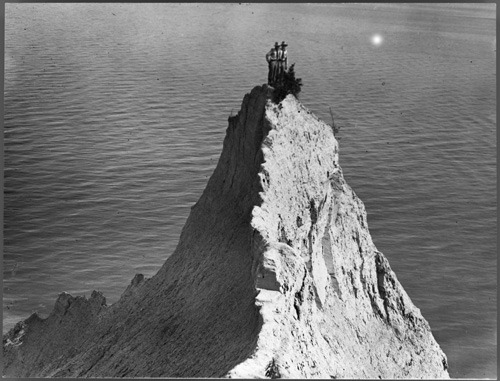
Photo: Scaling The Bluffs in 1909

I don't have much to say about this one, since the awesomeness kind of speaks for itself. Here are two people who have climbed to the tip of an outcrop at the Scarborough bluffs, in dress shirts and ties, in 1909. It's from one of the more helpful books I've come across, Toronto: An Illustrated History Of Its First 12,000 Years, which you can see more photos from here and buy here.